
The SASMAP Concept
Within SASMAP a holistic approach will be taken to locating, assessing, monitoring and safeguarding underwater cultural heritage. This will involve developing and utilising tools and technologies to allow “down-scaling” from the large scale regional level, moving on to the local site level and finally to the individual components of a site as shown in Figure 1.
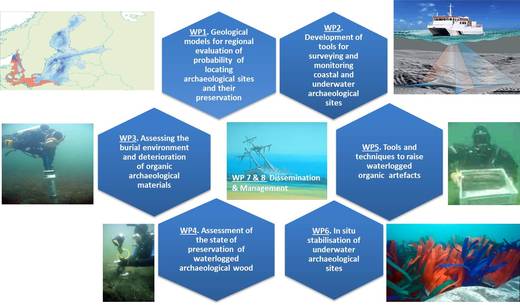
- Figure 1. A down-scaling and up-scaling approach to locating, assessing and managing underwater cultural heritage.

Results obtained from the down-scaling approach at the proposed study areas will show the effectiveness of such an approach for locating and detailed mapping of archaeological sites and their preservation potential. The end results of this approach will be used to develop a plan for assessing archaeological sites in European waters. From a management point of view this is an up-scaling approach to planning (bottom up). All information and experiences obtained during the course of the project will be utilised to enhance and develop existing legislation and best practice for mapping and preserving Europe’s underwater and coastal heritage.
SASMAP has multiple objectives that all have as their aim to develop a structured and optimized approach to safeguarding underwater cultural heritage. The objectives are:
• to develop regional specific geological models to understand palaeogeographic developments and use them to evaluate the probability of finding submerged archaeological settlement sites and of preserving them.
• to optimise the selection process of the target region ideal for non-destructive down-scaling studies based on the regional specific geographical models. Tools used will range from regional satellite scanning of theoretical optimal target areas, detailed multibeam and shallow seismic surveying of selected target areas to new development and innovative use of 3D shallow seismic investigations of identified targets. Data from these non-destructive studies will be directly applicable to Geographical Information System (GIS) presentation, interpretation and modelling of the physical appearance of the archaeological sites. The GIS will be custom made for input of hydrodynamic and sediment regime data in order to evaluate site stability and preservation status.
• to monitor biogeochemical parameters in typical littoral marine sediments by developing a data logging device. Measurements will be related to the degradation of organic archaeological materials in the marine environment and used to assess the preservation potential of sediments.
• to develop new technologies in the form of prototype diver-held tools for sampling sediment cores from archaeological sites, and tools for assessing the state of preservation of waterlogged archaeological wood.
• to develop and demonstrate innovative techniques to raise complex and heavily degraded waterlogged organic archaeological artefacts.
• to develop and monitor the efficacy of using artificial seagrass and other synthetic materials to stabilize sediments around archaeological sites. The durability (deterioration) of the synthetic materials most frequently used when preserving sites in situ will be assessed.
• to transfer knowledge and training in the use of the newly developed technologies through a field school and workshop. This will be aimed at potential end users of the SMEs involved and students, institutions, stakeholders and end users responsible for the management of underwater cultural heritage. Knowledge transfer will inform future generations of marine archaeologists and cultural resource managers about cutting edge technologies and marine spatial planning on a European scale.
The down scaling tools and methods outlined above will be trialled in the field on two shallow water submerged sites in Denmark (Tudsehage) and Greece (Cape Sounion). The up-scaling methods will be trialled on a shipwreck site in the Netherlands (BZN 10) and a submerged shallow water site in Italy (Underwater Heritage Park of Baia) (Figure 2). The geological and geographical characteristics of all these sites are significantly different. SASMAP will improve current best practice for protecting underwater cultural heritage. It is the intention to incorporate the resulting guidelines into European CEN standards (CEN /TC 346) concerning the protection and management of cultural heritage at the end of the project.
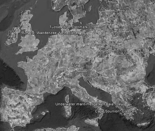
- Figure 2 Location of proposed sites for investigation in SASMAP
