
Status after the first year (WP6)
Burgzand Noord, The Netherlands
For years the Dutch Cultural Heritage Agency (RCE) has been working on the research and management of underwater cultural heritage. One of the focus areas of the RCE is the protection of archaeological sites for future generations. This principle is called in-situ preservation, and is also one the main points of the 2001 UNESCO Convention on the Protection of the Underwater Cultural Heritage.
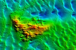
For SASMAP, Work Package 6 partners joined to test the new in-situ preservation method, namely artificial seagrass, developed by SSCS. The RCE tested this method on the wrecksite BZN10, a 17th century shipwreck which sank on the Texel Roads, east of the island Texel (Figure 1).
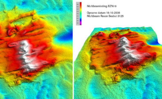
- Figure 1: Multibeam sonar image of the BZN wrecksite. Image by Periplus Archeomare B.V.

Wrecksite Burgzand Noord (BZN)
On this location, threatened by natural erosion, ships anchored between 1500-1800 ready for transport of goods at the Amsterdam harbour. Despite the shelter the island provided from Northwest winds, hundreds of ships sank. One of these was the merchant ship BZN10, which carried Iberian jars, slate, barrels of grapes and anchovy, and several small objects. Although the wreck has been physically protected for over 10 years, additional methods may be necessary to preserve if for future generations.
Protective measures
The current protection comprises a cover with scaffolding mesh, which catches sand. From the annual (2001-2013) monitoring of Texel Roads using multibeam sonar to reveal erosion or sedimentation, it was clear that a scour gully was threatening the archaeological site. Therefore new measures were necessary, making this a good location to test the artificial seagrass in these highly dynamic circumstances (strong currents, lots of sediment in the sea).
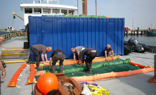
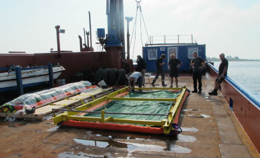
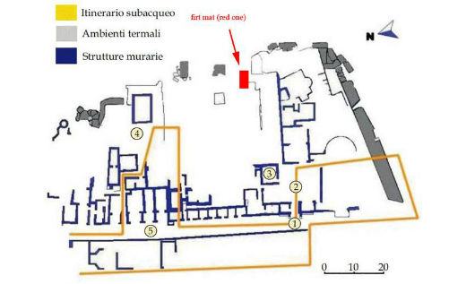
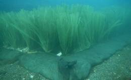
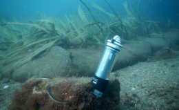
- Figure 2: Preparation of the artificial seagrass on the ship. Photo RCE Maritime Programme

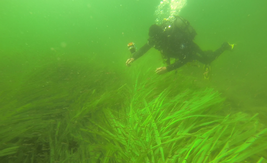
After a few days of preparation, on June 12th, four 2.5 × 5 metre mats were deployed on the BZN10 wreck. Frond lengths of 62.5 cm and 125 cm were used in order to find the most effective protection. The mats were placed on the south east corner of the wreck site in the order of a short frond mat, then two long frond ones, and finally a short one. By using the deployment frame developed by SSCS, the mats were placed in less than two hours in rough conditions and poor visibility.
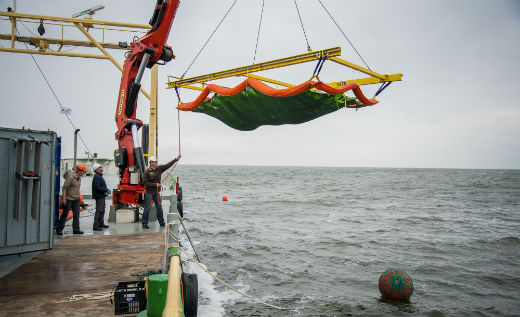
- Figure 3: The artificial seagrass is deployed on the wreck. Photo RCE Maritime Programme/ Paul Voorthuis
First results
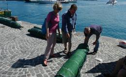
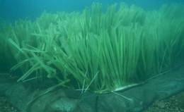
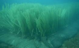
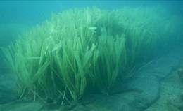
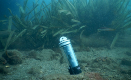
Six days later a first monitoring was carried out, by diving the site again. This revealed that the fronds had already caught a lot of sand. The short fronds seemed to work better, as they remained longer upright thus catching sediment. The longer fronds had a tendency to quickly lie flat because of the strong current, thereby losing their sediment catching-effect.
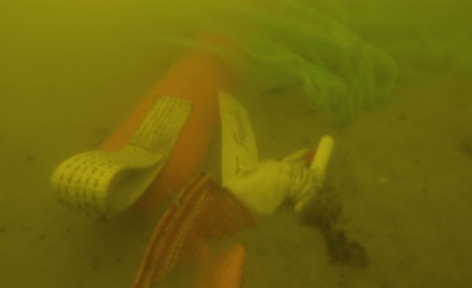
- Figure 4: After only 6 days the mats have caught some sediment. Photo RCE Maritime Programme

A second effect was that, because the fronds slow down the current, sediment had been caught up to two metres behind the mats. Because the layer of sediment caught by the fronds is dynamic (where sand is eroded, the fronds rise again, and start catching sediment), it could be a good method to protect the scaffolding mesh itself, which can easily be damaged. Monitoring over the next year will reveal if this effect persists.
First multibeam sonar results
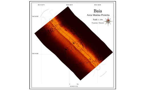
After a month the location was monitored again using multibeam sonar. This confirmed our first impressions that not only had the mats themselves trapped sediment, but behind the mats there was also sedimentation (Figure 5).
- Figure 5: Left- monitoring from 2012, without the seagrass.
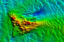
- Right- monitoring from July 2013 shows that the effects of the mats are already clearly visible (left bottom corner). Image by Periplus Archeomare B.V.
Artificial Seagrass, Netherlands
Tudse Hage, Denmark
Four frond mats were placed near the Danish site of Tudse Hage, a submerged Mesolithic site in approximately 2 metres of water, off the west coast of Sjaelland (Figure 6). The mats were not to be placed directly on the site, in order to be certain that the experiment did not negatively affect any archaeology in the area. Originally it was planned to use three standard mats with anchors for fixing and one edge weighted frond mat. All mats were green as opposed to the standard orange coloured. The mats were to be placed in four different areas. Just outside the area where archaeological remains are found (in ca. 2 metres water depth), to see if it could prevent and protect the areas closer to shore where cultural heritage was known to lie. As the standard frond size is 1.2 metres it was deemed that these may come too near to the water’s surface (the area is frequently visited by canoeists, fishermen etc.) and as with the Italian site green fronds of 0.8 metres were used. The three remaining mats were to be placed at 5, 7.5 and 10 metres water depth. The mats at 5 and 7.5 metres depths were standard mats with 8 anchors and 1.2 metre green fronds. The mat to be placed at 10metres was to be an edge weighted frond mat, again with 1.2 metre green fronds. Mats were generally oriented with the long edge (i.e 5 metres) in a north-easterly / south-westerly orientation in order to maximise the chance of catching sediment and dissipating currents running in from the Great Belt.
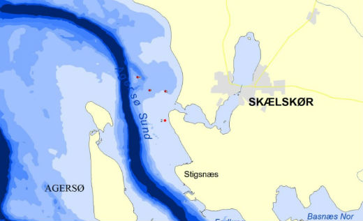
- Figure 6: Locations of the four frond mats deployed on the site of Tudse Hage. Drawing Viking Ship Museum

Initial trials were started in May 2013 (25 - 29th May) with the shallow water 2.5 metres mat. Normally, a hydraulic jackhammer is used to hammer the anchors into the seabed. Due to the requirements of large road compressors to do this, it was decided to trial the vibracoring system being developed in Work Package 3, together with a special spigot mounted to see if the anchors could be vibrated into the seabed – a synergy between the work packages which potentially may have made deployment of mats much easier.
The work was unfortunately hampered in the first instance by the initial placement of the mat in an area with a relatively thin layer of sediment overlying the compact clay rich natural subsurface. Because the anchors need to be 80 – 100 cm beneath the seabed in order to firmly anchor the mats, it was decided to move the mat. Furthermore the vibracorer, which has not been designed as a jack hammer, did not transfer enough energy to vibrate the large anchors into the seabed. It was therefore decided to move the mat to an area where the sediment overlying the natural substrate was ca 1 metre thick, yet still well away from the former coastline and outside the area of previous excavations. The original planned position was a clear area, but the only suitable location found was among scattered beds of natural seagrass, which had grown on the site in 2013. Finally an open area was located and a large 8 kg sledge hammer was used to hammer the anchors into the seabed – good experience had been gained with this method on the Haarbølle wreck. Because the Haarbølle wreck lies in a sandy seabed and the sediment of Tudse Hage is predominantly a thick organic gyttja, it took two divers, three hours to hammer the eight anchors into the seabed.
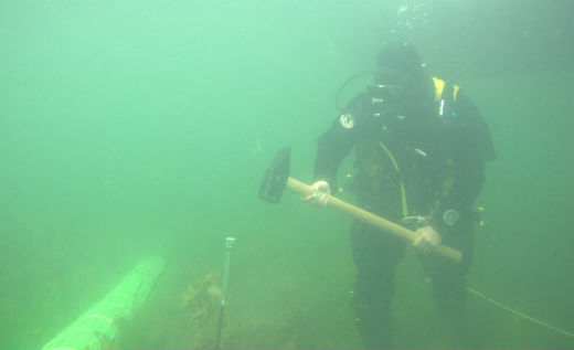
- Figure 7: Diver hammering a seagrass anchor into the seabed. Photo Viking Ship Museum

Based on this experience and the length of time taken on the most shallow site together with the number of diving cylinders required and with the risk of bad weather hampering the operation, it was decided to re-think deployment of the mats. After discussion with SSCS it was decided to use edge weighted anchor mats for the 5 and 7.5 metres areas – the original plan was to use such a mat on the 10 metres area.
The mats were rapidly prepared and shipped to the warehouse facilities of JD-Contractor A/S in Kalundborg, Denmark (http://www.jydskdyk.dk/) who had very kindly and generously offered to support the project with a jackup vessel, Marcos, that had a crane and crew helping deploy the Edge Weighted mats in the desired positions and was on its way from Nyborg to another job via Tudse Hage.
- Figure 8: Marcos, used to deploy the Edge Weighted Frond Mats in Tudse Hage. Photo: Viking Ship Museum

The logistics came together with the mats being loaded onto the ship and the frame being transported to Nyborg to meet it. On Sunday the 7th July, divers and a photographer from the Viking Ship Museum, along with Alan Hall from SSCS met in Skælskør harbour and sailed out to meet the Marcos. In the meantime the crew of Marcos had assembled the frame with the first mat ready for deployment and following instructions from Alan the mat was lowered into the water to a depth of 3.7 metres.
- Figure 9: Alan from SSCS makes final checks to the mat before deployment. Photo: Viking Ship Museum

Divers from the Viking Ship museum followed and filmed the process under the water. The mat was moved into position by divers, positioned on the seabed and the safety net covering the plastic fronds released. The system, just as in The Netherlands, worked perfectly. Following this successful deployment Marcos moved to the next area (7.5 metres) and the process was repeated. On lowering this mat it was noticed that the webbing strops which the fronds are attached to were bowing. This was attributed to the edge weighted system not being fully taut. However, this was remedied by a diver stretching out the weighted bags at the edge of the mat – a relatively easy process for a single diver. Again the safety net and fronds were released without due concern. Marcos relocated again and the final mat was deployed in 10 metres of water – again with no problems.
The final mat took 6 minutes to deploy from leaving the surface to the fronds being released. The total time spent deploying the three mats was approximately 3.5 hours and the general feeling, certainly from those who had sledge hammered the anchors of the first mat into the seabed was that the new design of mats and method of deployment was a lot easier than the conventional anchoring system. Following deployment the mats were surveyed using single beam echo sounder (SBES) at a close line spacing as a way of monitoring any changes in the seabed topography and to see if there is any deposition of sediment on the mats and development of any scour pits around the mats.
Monitoring
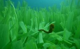
Following the deployment of the mats and in connection with the work carried out in Work Package 3, the mats were re-visited in August (20-24th) and survey carried out using the SBES again. The mats were accessed by divers from the Viking Ship and National Museums with video and still images being taken. The post- processing of the SBES data is pending and the use of the method will be validated prior to the next phase of monitoring in the winter of 2013-2014. Although there was no sign of sediment accretion on any of the mats (there had not been any particularly heavy weather in the time since deployment) what was particularly interesting to note on all mats and particularly those at 10 and 7.5 metres, where there was no surrounding seagrass or vegetation in the area, was that they were a haven for various fish and fish fry and it certainly appeared that the mats were acting either as a nursery or an area of protection for these fish. Species of fish present were slightly different at the various depths and it is being considered whether more work should be done on classifying the types of fish present.
- Figure 10: School of fish fry in and around the frond mat placed in 5 metres of water.

Further to the monitoring and in connection with WP3, the open water datalogger being developed was placed on the 5 metres mat (Figure 10). This was situated on the onshore and offshore sides of the long edge of the mat and logged for two days in each location. The logger records CTD data (conductivity, temperature and depth) and current strength and direction. In this way it was intended both to trial the logger but also gain information about the environment around the 5 metres mat.
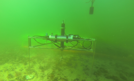
- Figure 11: Open water data logger developed by Unisense being trialled on the 5 metre deep frond mat.

Artificial Seagrass, Denmark
Baiae Deployment, Naples (Italy)
The artificial seagrass mats were placed in the Underwater Archaeological Park of Baiae, Naples from June 26th 2013 to July 6th 2013.
In order to install the artificial seagrass the Istituto Superiore per la Conservazione ed il Restauro (ISCR) Team (Dr Barbara Davidde director of the SASMAP’s ISCR activities, the architect Filomena Lucci and the scientific researcher Gabriele Gomez de Ayala) was joined by SASMAP partners Dr David Gregory from The National Museum of Denmark, Mr Jørgen Dencker from The Viking Ship Museum and Mr. Brian Smith and Mr Alan Hall from Seabed Scour Control Systems. Dr. Paolo Caputo, director of the MPA of Baiae (Soprintendenza speciale per i Beni Archeologici di Napoli e Pompei) and the underwater restorer Salvatore Carandente (SSBANP) also participated and we want to thank them for their cooperation.
The archaeological site of Baiae (Naples)
Baiae was a famous seaside town much prized in antiquity for its temperate climate, beautiful setting and the properties of its mineral waters that have been exploited since the second century B.C. It was the most popular resort among the Roman aristocracy and the Imperial family up until the end of the fourth century A.D., when a bradyseism i.e., gradual changes in level of the coast in relation to the sea level that have been positive and negative, caused the submersion of the city. Environmental problems in this area are related to a particular volcanic and deformational history. This coastal region has been characterised by periodic volcanic and hydrothermal activity and it has been subject to bradyseism. With the passing of millennia the original archaeological complex has been submerged and the archaeological remains are still underwater.
Today the remains of the luxurious maritime villas and imperial buildings, more modest houses, private thermae, tabernae, roads and warehouses and all the architectonic structures that characterise the cities of the Roman Age, lie underwater at a distance of up to 400 to 500 metres from the coast at a depth of 5-7 metres.
The interaction between natural processes and human activity has produced a marine environment characterised by a huge variety of natural habitats. For this reason in 2002 an Underwater Park, Marine Protected Area (MPA) was created covering around 176.6 hectares. The submerged area includes part of the territory of the ancient city of Baiae and Portus Iulius, comprising the Roman harbour and numerous constructions used as warehouses.
Today, visitors to Baiae MPA can choose between a number of guided tours including the Villa con ingresso a protiro, the Villa of Pisoni (with mosaics, thermae and mansory), the Ninpheum of Punta Epitaffio (including copies of statues of the imperial families), the Portus Iulius and of “Secca Fumosa” (a series of 12 massive pillars recently recognised as the remains of the Thermae built in the sea by Marcus Licinius Crassus Frugi mentioned by Pliny by Pausanias). These tours are open to the diving public and to non-diving visitors that can the visit on a boat fitted with a transparent keel.
Two thermal plants are also located in this area, together with the villa’s marine quarter – situated in the south of the courtyard – that included two landings with a quay, tanks to collect water and fishponds. The sea quarter was defended by twenty-five pilae inserted on the sea bottom.
The residential part of the villa has not been found yet. The architectural decorations still existing are made of marble, stuccos and polychromatic paintings.
The Villa con ingresso a protiro
The complex of the Villa con ingresso a protiro (Figure 12) is located at a depth of 5 metres. The villa underwent a second construction phase represented by the building of a wide apsidal room south of the hall. The room had two floor levels, built from large white marble sheets which were used as covers for the walls as well.
Deployment of the mats
Villa con ingresso a Protiro
In this location the effects of the artificial sea grass on the environment will be tested. The dimensions of the mat are 2.5 × 5 metres, with 1.25 metres long orange fronds. The location was monitored prior to the placement on 6th July 2013 and after the placement on 6th September 2013.
- Figure 12: Map of Villa con ingresso a Protiro

Artificial Seagrass, Italy
Initial results
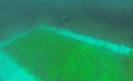
As the mat is populated by different species of fish (Figure 13), it appears to be well integrated into the marine environment. ISCR biologist Sandra Ricci will continue the study on the biological colonisation of the fronds of these mats and of the others positioned in the Villa dei Pisoni.
- Figure 13. Fish populating the mats after installation. Photo: ISCR


Villa dei Pisoni
After long deliberation it was decided to change the planned position of the mats. The part of the wall of the viridarium of the Villa dei Pisoni originally chosen proved to be unsuitable, as a lot of archaeological structures collapsed near the wall, which could have a negative influence on the results.
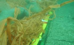
Mats of dimensions 5 × 1 metre (1), 7 × 1 metre (1), 5 × 2.5 metres (1) and 5 × 2 metres (3) were installed (Figures 14A-B, 15A-C, 16A-E). All the six mats had short green fronds (0.625 metre). But as it was impossible in Baiae to use a large ship with crane, necessary to place the edge-weighted mats, a new method for anchoring the mats had to be found. SSCS developed a special skirt around the edges of the mat, on which sandbags could be placed to weigh them down. Although this system requires the filling of a lot of sand bags (in Baiae 150 bags filled with around 4500 kg’s of sand were used), it proved to be easy in use with smaller boats and kept the mats in place.
- Figure 14A-B: Arrival of the mats. Photo: ISCR


- Figure 15A-C: Placing of the sandbags. Photo: ISCR


- Figure 16A-E: Installation of the mats

- Figure 16F: The first visitor

Monitoring
The following equipment is being used by Gabriele Gomez de Ayala, a ISCR collaborator, to monitor the site:
- SSS Ecocos (high variable frequency side scan sonar)
- HD Dynamic (dynamic positioning system)
- SensCos (current direction and intensity, light and temperature sensors) (Figure 17-21)
- Naumacos L3 3D scanlaser
- Figure 17: Side Scan Sonar of the research area on 6th September 2013. The scan shows the position of the 6 mats placed to protect the ancient remains of Villa dei Pisoni

As sedimentation of soft sand continues, the seabed becomes softer. Therefore seabed hardness is an indication of sedimentation. The lower the seabed hardness value, the softer the seabed. The research area was monitored before, and 2 months after the placement of the mats. As figure 18 shows, the seabed became softer, showing that sedimentation took place.
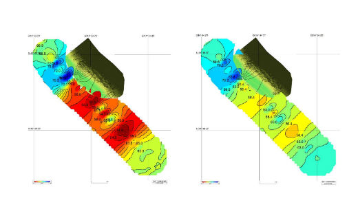
- Figure 18: Left-seabed hardness 6th July 2013. Right-seabed hardness 6th September 2013

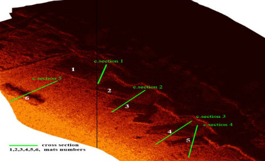
- Figure 19: Position of the 6 mats, the green line represents the cross sections.

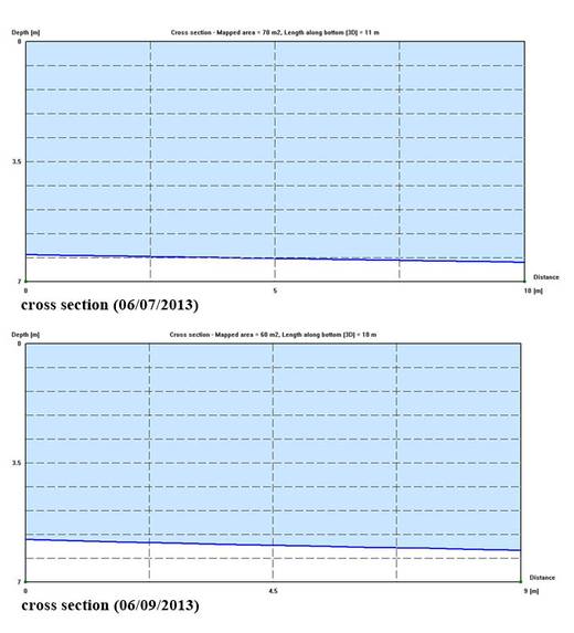
- Figure 20: The selected cross section shows the homogeneous distribution of soft sand (about 25 cm on the edge of the ancient wall) over the seabed between mat 1 and mat 2. The build-up of sediment is clearly visible after the second monitoring.

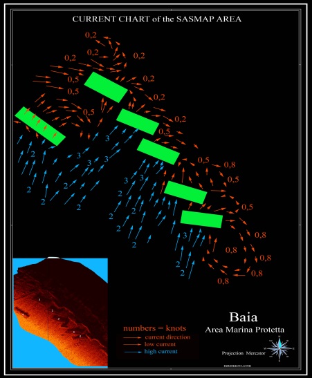
- Figure 21: Chart of the current distribution in the area examined in SASMAP

Assessing the durability of materials used in the in situ preservation of underwater archaeological sites
- Figure 22A-B: Mat 1 on 6 th July 2013. Photo: ISCR


- Figure 23A-B: Mat 2 on 6 th September 2013. Photo: ISCR


- Figure 24A-B: Mat 3 on 6 th September 2013. Photo: ISCR


- Figure 25A-B: Mat 4 on 6 th September 2013. Photo: ISCR


- Figure 26A-B: Mat 5 on 6 th September 2013. Photo: ISCR


- Figure 27A-D: The SensCos (current direction and intensity, light and temperature sensors).

- The sensor works 24h, 7 days a week. Photo: ISCR

Examination of Plastics
Background
Plastics such as sandbags, geotextiles and debris netting have often been used for mitigating the deterioration of underwater archaeological sites. The chemical types, manifestations of degradation and breakdown pathways in fresh and saltwater have not been established. Because it is important to understand how long plastic materials can protect underwater cultural sites and to ensure that degradation of these plastics will not have environmental consequences, samples of the materials after use have been collected from sites managed by SASMAP members and their properties are being investigated at the National Museum of Denmark. Data will be used to assess their suitability for use with cultural heritage and ultimately to develop guidelines for selecting materials for use by cultural heritage managers.
Collection and preparation of samples
Samples of plastics were removed from archaeological sites underwater up to one year before they were evaluated. In order to slow their deterioration after collection and to avoid contamination, they were stored below ambient temperature and without direct contact to other plastics. Researchers at San Diego University who collected samples of plastics from San Diego Bay developed a protocol for storing samples that was adapted for SASMAP and is summarised below (Rochman, C.M et al., Long-term field measurement of sorption of organic contaminants to five types of plastic pellets:implications for plastic marine debris, Environmental Science & Technology, 2013, 47, pp1646-1654):
- dry removed plastics as much as possible with kitchen roll
- wrap samples in aluminium foil or aluminium trays
- enclose wrapped samples in resealable, polyethylene bags
- place bags with clear labels in a domestic freezer at -20°C
- 24 hours before evaluation, allow samples to warm to ambient without removal from their polyethylene bags
Examination of samples, visible light and ultraviolet examination
In addition to examination in visible light, plastics are examined in ultraviolet (UV) light at wavelengths between 320 and 380 nm produced by a UVA-Spot 400/T supplied by Deffner and Johann. Many biological materials, especially active ones, fluoresce when exposed to ultraviolet light. They absorb ultraviolet light and re-emit it almost instantaneously. Because energy is lost during the absorption process, the emitted light has a longer wavelength than the incident which causes the material to glow or fluoresce. Plastics that have been moulded or cast contain UV absorbers from manufacture and therefore appear black in UV light.
Findings from examination by ultraviolet radiation
Exposure to UV radiation was effective at distinguishing biological materials from their plastic substrates despite both being similar colours in some cases and the technique will, therefore, be applied to all plastics examined in SASMAP. Of the plastics examined, only RCE8, a blue, loose woven scaffolding net from south side BZN10 installed in 2001/2 and Greece 1, a hard white plate with numbering in marker pen and rust showed no evidence of active biological attack.
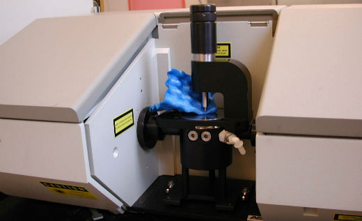
- Figure 28A: Analysis using Attenuated Total Reflection – Fourier Infrared spectroscopy requires no sample preparation or destruction

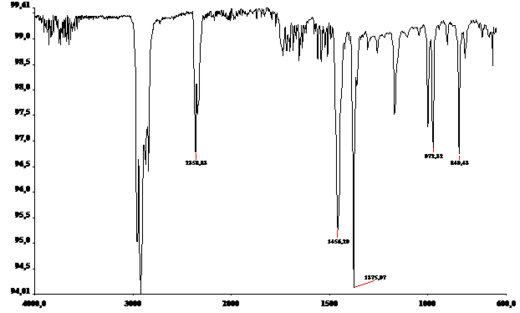
- Figure 28B: The FTIR spectrum shows that the chemical groups producing the peaks are identical to those in polypropylene

Examination by infrared spectroscopy
Polymer types in plastics and, where possible, any changes in chemical structure induced by being under water for at least 5 years were identified using non-destructive Attenuated Total Reflectance-Fourier Transform Infrared (ATR-FTIR) spectroscopy (Figure 28). ATR-FTIR is a standard technique to detect the loss or development of chemical groups present in polymers and additives in plastics eg plasticizers, anti-ageing additives. It can be used non-destructively. The technique is poorly sensitive to changes at the initiation of degradation but more sensitive to degradation at propagation stages (degradation in progress).
The surfaces of all samples were examined using a Pike MIRacle accessory fitted with a zinc selenide crystal in a Perkin Elmer Spectrum 100 spectrometer. Spectra were collected over 30 scans at a resolution of 4 cm-1 between 4000 and 600 cm-1. Spectra were compared with reference spectra run on the same instrument at the National Museum of Denmark.
Initial results
It is evident that the chemical composition of plastics cannot be determined from appearance alone. Scaffolding nets were made either of polyethylene, polypropylene or nylon despite appearing similar.
All plastics show signs of chemical changes after use under water with the exception of polymethyl methacrylate. This finding was interesting and unexpected because these plastic types have different degradation pathways and therefore would not all be expected to degrade under aquatic conditions. Polypropylene seemed more resistant to degradation than nylon 6.6 and polyethylene, which was physically degraded and readily stained with rust and biological materials. Polymethyl methacrylate was the most stable and polyethylene the least stable plastic for underwater use from this investigation.
It would be useful to know the oxygen content, temperatures and ultraviolet levels in the microclimates around the various plastics in order to further interpret the findings.
Preliminary conclusions
To test the artificial seagrass mats, three sites were selected in three different countries. Because of these different locations, the mats are tested in the most diverse circumstances. From the calm shallow waters of the bay of Naples, to the low current sea in Denmark and the rough Waddensea with its strong tidal movement, each of the sites has its own specifics. First of all the placement of the mats will be discussed. In both Denmark and The Netherlands the system of edge-weigthed mats was used. In both sites a big ship with heavy crane was used to place the mats. As it took only a couple of hours on each site to place all the mats, this can be regarded as a great success. Although there were some minor adjustments in The Netherlands (more suspension for the centre of the mat was needed), the weighted edges worked very well. Even in the rough tidal conditions the mats remained in their place.
In Baiae , Italy it proved to be impos-sible to use the big machinery to place the seagrass. The solution was to extend the edges on which sandbags were placed. Although filling and placing the sandbags took quite some time, it proved to be an adequate solution.
As expected, the strong tidal action and high sediment transport in the water caused the mats in The Netherlands to trap a lot of sediment. A surprising effect was that, because of the slowing of the current by the fronds, also 2 -3 metres on both sides of the mats sedimentation took place. After the first diving monitoring the shorter (0.625 metre) fronds appeared to work better, because the longer ones became trapped earlier under sand. In Denmark there was no visible sedimentation. Processing the data in the near future should reveal whether sedimentation has actually occured. Also comparing the data from the datalogger could be useful, as this will reveal the strength of the current and the amount of sediment suspended in the water.
Although there is very little current in the bay of Naples, some sedimen-tation did take place. Between mats 1 and 2 almost 50 cm of sediment was deposited. As expected the mats also caught soft sediment, as is visible in the cross section and hardness maps. It is expected that this sediment will cover the wooden structures.
Examining the plastic remains also revealed some interesting new information. After the initial investigations the plastic polymethyl methacrylate appears to have undergone no degradation, which would make it very suitable for protective materials. But as most of the research will take place in 2014, it is too early for definite conclusions.
Further research
In the next year monitoring of the mats will take place again using different methods: visual inspection, different sonar systems and 3D measuring systems. This monitoring should reveal what the mid-term effects of the artificial seagrass mats are. Is the sediment trapped on the mats themselves stable, or moving? And how does it effect the immediate surroundings?
Secondly the plastic-samples from the previous in-situ measurements will be further investigated by Yvonne Shashoua from the National Museum of Denmark. Hopefully this will reveal which materials are best to be used when trying to preserve an archaeological site in situ.
Finally the sites will be examined using the 3D-subbottom profiler being developed in WP2 in order to find out how the sediment is built up.
Thijs Coenen, Martijn Manders, Barbara Davidde, David Gregory, Yvonne Shashoua, Brian Smith and Jørgen Dencker